
ဝှာင်:Australia satellite plane.jpg

ဇမၞော် နမူနာ ဏအ် - ၇၂၉ × ၆၀၀ pixels အရာမသ္ဂုတ်သွာတ်လဝ်ဂမၠိုၚ်: ၂၉၂ × ၂၄၀ pixels | ၅၈၃ × ၄၈၀ pixels | ၉၃၃ × ၇၆၈ pixels | ၁၂၄၅ × ၁၀၂၄ pixels | ၂၄၈၉ × ၂၀၄၈ pixels | ၅၂၅၀ × ၄၃၂၀ pixels တၞဟ်။
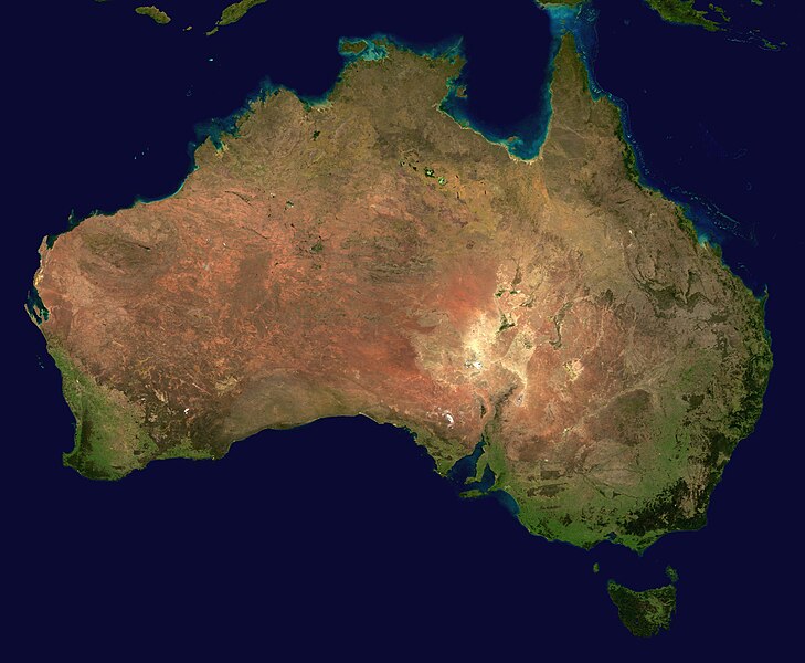
ဝှာင် တမ်မူလ (၅၂၅၀ × ၄၃၂၀ pixels, file size: ၁.၇၆ MB, MIME type: image/jpeg)
| ကဵုယၟု | ||||||
| တမ်ရိုဟ် | The image is from here, specifically http://visibleearth.nasa.gov/images/2433/land_shallow_topo_east.tif land_shallow_topo_east.tif, which was cropped at 5250x4320+13390+11880. | |||||
| ကဝိ | Reto Stöckl / NASA Goddard Space Flight Center | |||||
| တင်မကဵုအခေါင် (ကလေင်သုင်စောဲ ဝှာင်ဏအ်) |
|
|||||
| အခြား ဗားရှင်းများ | Derivative works of this file: Australia satellite states.jpg |

|
ဝှာင် လၟေင်အပြံင်အလှာဲ
ဍဵု လတူ စၟတ်တ္ၚဲ/အခိင် မွဲမွဲ သွက်ဂွံ ထ္ၜးကဵု ဝှာင် မကတဵုဒှ်လဝ် ပ္ဍဲအခိင်ဂှ်၊၊
| စၟတ်တ္ၚဲ/အခိင် | ဗီုပြင်နမူနာ | ပမာဏ | ညးလွပ် | တင်ပသောင်ကလး | |
|---|---|---|---|---|---|
| လၟုဟ် | ၂၃:၂၈၊ ၁၉ မေ ၂၀၀၅ | | ၅၂၅၀ × ၄၃၂၀ (၁.၇၆ MB) | Dbenbenn | high resolution version. Cropped land_shallow_topo_east.tif at 5250x4320+13390+11880 |
| ၀၃:၄၀၊ ၁၄ နဝ်ဝေမ်ဗါ ၂၀၀၄ |  | ၈၀၀ × ၆၇၂ (၈၄ KB) | Bjarki S |
ဝှာင် ဗီုဂွံစကာ
အရာမဆက်ဗက်ကၠုင် page links ကုဝှာင်ဏအ် ဂမၠိုင်ဂှ် -
ဝှာင် သွက်ဂွံသုင်စောဲ ဂလုပ်ဗဴ
ဗွဲသၟဝ်ဏအ်ဂှ် ဒှ်အရာ ဝဳကဳတၞဟ် မစကာလဝ် ဝှာင်ဏအ်၊၊
- ဗီုစကာ ပ္ဍဲ af.wikipedia.org
- ဗီုစကာ ပ္ဍဲ an.wikipedia.org
- ဗီုစကာ ပ္ဍဲ ar.wikipedia.org
- ဗီုစကာ ပ္ဍဲ ar.wiktionary.org
- ဗီုစကာ ပ္ဍဲ arz.wikipedia.org
- ဗီုစကာ ပ္ဍဲ ast.wikipedia.org
- ဗီုစကာ ပ္ဍဲ azb.wikipedia.org
- ဗီုစကာ ပ္ဍဲ ba.wikipedia.org
- ဗီုစကာ ပ္ဍဲ be-tarask.wikipedia.org
- ဗီုစကာ ပ္ဍဲ be.wikipedia.org
- ဗီုစကာ ပ္ဍဲ bh.wikipedia.org
- ဗီုစကာ ပ္ဍဲ bn.wikipedia.org
- ဗီုစကာ ပ္ဍဲ bo.wikipedia.org
- ဗီုစကာ ပ္ဍဲ br.wikipedia.org
- ဗီုစကာ ပ္ဍဲ ca.wikipedia.org
- ဗီုစကာ ပ္ဍဲ ce.wikipedia.org
- ဗီုစကာ ပ္ဍဲ ckb.wikipedia.org
- ဗီုစကာ ပ္ဍဲ cs.wikipedia.org
- ဗီုစကာ ပ္ဍဲ cy.wiktionary.org
- ဗီုစကာ ပ္ဍဲ da.wikipedia.org
- ဗီုစကာ ပ္ဍဲ de.wikipedia.org
- ဗီုစကာ ပ္ဍဲ de.wikivoyage.org
- ဗီုစကာ ပ္ဍဲ de.wiktionary.org
- ဗီုစကာ ပ္ဍဲ diq.wikipedia.org
- ဗီုစကာ ပ္ဍဲ dz.wikipedia.org
- ဗီုစကာ ပ္ဍဲ el.wikipedia.org
- ဗီုစကာ ပ္ဍဲ en.wikipedia.org
ဗဵု more global usage ဝှာင်ဏအ်၊၊